UrbanStat has classified over 95% areas that burned in Dixie Fire as high or worse risk
California’s Dixie Fire has been exploding in size in recent days due to high winds and hot temperatures. Currently the fire is in the top 20 of largest fires in California’s history based on Cal Fire data.
As the fire started growing in size, we decided to take a closer look into our model’s performance. For those who are not familiar with UrbanStat’s wildfire research, UrbanStat releases a wildfire risk map for California and 4 other states in the west coast every year prior to the wildfire season. Then at the end of the wildfire season we evaluate our performance and release our results.
Occasionally, we look at current wildfires and release initial results as the fires get bigger in size in a short period of time. As you can see from the screenshot below, Dixie fire is, for the most part, burning in High or worse risk areas according to UrbanStat’s wildfire risk map.
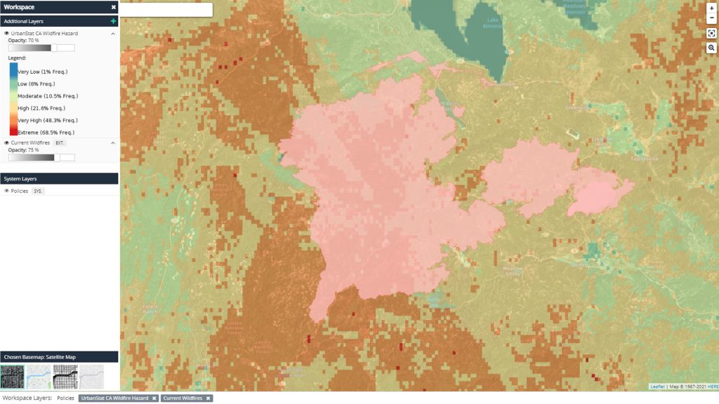
Based on the fire perimeter data and our risk map, over 95% of the burned areas were classified as High or worse risk in January, 2021.
If you are interested in learning more about our wildfire research, do not hesitate to contact us.
About UrbanStat
UrbanStat helps insurers better predict the “make or break” claims at the time of underwriting. Its core technology – a fully-automated underwriting API – uses a unique ensemble of geographic modeling, statistical modeling, machine learning, and human intelligence. Besides underwriting automation, UrbanStat offers end-to-end analytic solutions that enable underwriters, risk engineers, reinsurance managers, and C-level managers to prepare and access tabular, visual and spatial reports for their portfolio within seconds. For more information, visit urbanstat.com